Massachusetts Bay Transportation Authority Green Line
The MBTA Green Line is the oldest American subway, opening in 1997. In 2010, the Green Line had a total ridership of 236,096, which includes both light rail and trolley. The Green Line spans 23 miles of operation, and the MBTA is currently in the process of planning a 4.5 mile extension. The extension has been in active planning since 2005.
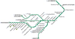
The extension will take the Green Line service from East Cambridge terminal into the communities of Somerville and Medford, which are northwest of downtown Boston, according to Kate Fichter, manager of long-range planning for the Office of Transportation Planning-Massachusetts Department of Transportation.
“The green line right now, the northwest terminus of the green line, is in East Cambridge. It crosses the river from Boston to Cambridge. There’s one station in Cambridge, which is an old station; there’s been transit service there for a long time. There have been ideas and visions and plans for many decades to try and keep it going. There was once much more trolley service in the area; today there’s nothing,” says Fichter.
Fichter says the project has a huge amount of public knowledge and support, and as a result MBTA hasn’t done much to sell the public on the project. “Everyone wants it yesterday.”
“To date we’ve talked more about it in terms of other diversions because there are quite a few bridges that we’d need to reconstruct so the trains could pass under them. In terms of new transit routes, not a lot. We’ve done some preliminary planning on whether there’d be any changes to the bus routes,” Fichter explains. “I think everybody just wishes they could ride it right now. People are ready to go. “
Project Status
The state level environmental review was finished more than a year ago, and currently MBTA is almost finished with the federal level review. “Public commentary for that will be starting in a couple weeks. We are working our way through advanced conceptual design,” Fichter says.
While no ground has been broken yet on the project, Fichter estimates construction will begin sometime in the next two years. “We’re looking at a couple different options right now. It’s hard to say [when construction will start] because it will depend on what construction methodology we use. It’s a little premature to estimate, certainly.”
Fichter adds: “The real question is whether we decide to do a phased implementation. This is an idea we’re playing with right now. That would allow us to open certain stations for revenue service while other stations are still in construction. When we started the project we imagined that the whole project could open all at once, but it looks like there might be some advantages to doing it piecemeal. If we did that, we would probably be starting construction in the next year, which we don’t know yet if we’ll do that.”
Fichter roughly estimates that the full expansion will be operating sometime between 2017 and 2020. However, she stressed it is still too early to know for sure.
Future Plans
While there are no definite plans for additional expansions in the future, there is potential for some. Fichter says that the environmental review included one additional station on the far end of the line. At this time that portion of the project isn’t progressing though.
“We’re not currently progressing that part of it into design and construction, but we could in the future. Most of the environmental work is done, so it would just be to design and construct it. But the potential would bring it up to a station called the Mystic Valley Parkway,” she says.
Dallas Area Rapid Transit - Green Line, Orange Line and Blue Line
Dallas Area Rapid Transit has been busy. The recent Green Line extension opened in December 2010, and there are two more extensions currently in the works. The light rail system, which currently covers 72 miles and includes 55 stations first opened for operation in June 1996. Morgan Lyons, director of media relations at Dallas Area Rapid Transit, says that by 2014 the system will cover 90 miles and by 2018 or 2019 it will be at 93 miles, when the South Oak Cliff extension is completed.
“The Green Line is what we finished last year, and it basically runs from the southeast to the northwest – from southeast Dallas on through downtown Dallas where it runs along with the Red and Blue lines and then continues through northwest Dallas and then goes up to the cities of Farmers Branch and Carolton. It gets us, most of the light rail has been to the north central and northeast and then southwest and south central, and so this gives us a whole new set of directions, connections,” Lyons says.
Project Status
DART currently has two extension projects both in construction. On the Orange Line, the extension is comprised of three components, Lyons explains. The first section takes the line from the Bachman station to the Irving Convention Center and it is currently in construction and on schedule to open in August 2012. The second section is also under construction, which goes from the Irving Convention Center to the Belt Line station, which is near DFW airport. This portion is scheduled to open in December 2012.
“The final section of the Orange line, which goes from DFW Terminal A in the airport, we plan to have that award a contract at the end of this year or first of next. So we can open December 2014,” Lyons says.
The Blue Line extension will take the line from Garland out to downtown Rowlett, Lyons says. The extension will cover about five miles and extends the line to the northeast.
Future Projects
“We’re also doing planning for another Blue Line extension, which would come from our Ledbetter Station. It’s about a 3 mile extension to the Dallas campus of the University of North Texas. You’ll literally be connected to two campuses on the UNT system. That’s 2018, 2019. We would like to try accelerate it; we still have some planning to do there’s still work to do,” Lyons says.
Lyons says there are also plans for a second light rail alignment through downtown Dallas; however it is not part of any immediate plans.
A third project that is in the works is the Cotton Belt. “That is an east-west line that would come from our Red Line around the Bush Turnpike station and travel to DFW airport,” Lyons explains, “and then we actually own the corridor all along this area into the north side of Fort Worth.”
In addition, Lyons says the Fort Worth T has plans for a line on the west side of the Cotton Belt corridor that would come from southwest Fort Worth and meet up with the DART corridor on the north side of Fort Worth, connecting to DFW airport.
“That would actually be a light rail new technology vehicle. It’s a type of vehicle, a diesel hybrid vehicle we’re trying to develop. It would not be a traditional electric light rail vehicle. We’re continuing the planning for that,” Lyons says. “There’s a lot of regional interest in it. We’re looking at innovative financing and other planning groups in the Dallas area are looking at that.”
Hampton Roads Transit The Tide
The Tide, Hampton Roads Transit’s (HRT) light rail line extends 7.4 miles from the Eastern Virginia Medical Center complex east through downtown Norfolk and adjacent to I-264 to Newtown Road. There are 11 stations along the line, which just opened in August 2011, and its daily ridership so far is averaging out to around 6,000 weekday riders.
Tom Holden, HRT public affairs manager, says that while the system has only been open a few months the launch has been a success. “It’s doing much better for the average daily ridership than was originally projected,” he says.
“I feel pretty comfortable saying it’s been very warmly received. There’s a terrific amount of interest in it. A lot of folks wanting to see The Tide extended into Virginia Beach,” says Holden.
Before the new service was launched, HRT conducted an extensive safety outreach program with the public and all the schools that are located along the line, Holden explains. The Light Rail S.A.F.E.T.Y campaign stands for: Stay Alert! Don’t Get Hurt!, Any Time is Train Time!, Forget Shortcuts!, Everyone Should Obey Signs and Signals!, Tracks are for Trains!, You! Safety Starts with You!.
“We worked very hard to convey safety messages to the public about being safe around light rail. We had outreach programs into the middle, high and elementary school districts to make sure we got into all the schools that were along the light rail alignment so we could teach the students and teachers about light rail safety,” Holden says.
Fare Collection
The Tide uses an off board fare collection system through ticket vending machines on the platform or through a new e-ticketing service.
“I think we’re among the very few transit agencies in the United States that has an online ticket purchase option,” Holden says.
Each platform has two ticket vending machines, however during major events the machines were overwhelmed and customers were unable to get their tickets quickly enough, explains Holden.
“It’s pretty unusual. You can get an email confirmation and a QR code sent to your smart phone and then you can ride the rail that way,” he says.
Online fares are good for one person to ride all day on The Tide light rail. However, they are not valid for HRT bus, ferry, paratransit or other HRT services.
Future Extensions
HRT has been conducting the Virginia Beach Transit Extension study (VBTES) to examine the best transit options available for a former freight rail right of way that runs from Newtown Road to Birdneck Road in Virginia Beach. The study includes options for extending transit service east of Birdneck Road to the Oceanfront.
Four alternatives are being considered: extending The Tide light rail into Virginia Beach, building a bus rapid transit line, enhancing local bus service or doing nothing at all. However, the study is currently on hold until nine to 12 months of ridership data from the Norfolk line of The Tide can be gathered. After the data has been collected, HRT will restart the VBTES, currently anticipated in the third quarter of 2012. The study is expected to be completed by the end of 2013.
If things move forward, the Virginia Beach extension would cover 10.8 miles and included eight stations.
Calgary Transit CTrain
Calgary Transit’s light rail system, CTrain, is comprised of two lines – the Route 201 Crowfoot/Somerset-Bridlewood and the Route 202 McKnight – Westwinds/City Centre. The original legs of the system opened in 1981; today the system covers a total of 28.5 miles and includes 26 major stations. Eight percent of the system runs underground.
Ron Collins, Calgary Transit communications coordinator, says for 2010, the ridership was 94.4 million and in 2009 it was 94.2 million. The CTrain is operated by wind generated electricity, the only system in North America to do so.
“What it means really is the CTrain, our light rail transit system, is 100 percent emissions free. So it’s very good for the environment, a very green system,” Collins says.
Calgary is a growing community, and with that population growth comes a number of extensions to the CTrain.
“The city of Calgary is likely the fastest growing community in Canada. Our plan is to just try and keep up, keep base with the demand for service. That is our challenge right now,” Collins says. “Ridership has actually increased by about 25 percent since 2001. Since 2001 we’ve actually doubled our track system. By the time the West LRT opens, we’ll have a track of just over 50 km.”
Extension Projects
The largest of the three extensions currently in process in Calgary is the West LRT extension. The West LRT is the first new line in 20 years, according to Christian Cormier, spokesperson for the West LRT, and will be 4.9 miles long and will have six new stations.
“There’s the first elevated station of the network that will be part of the new line and the first underground station in Calgary,” Cormier says. “It’s quite a complex line when you look at it because part is at grade, part is elevated, and part is underground. The project also includes elements like an interchange, a lot of elements that are above and beyond the actual LRT alignment.”
The project budget for the West LRT was approved in 2007 and after a year’s worth of community meetings, the project went to market in 2008. Cormeier says the contract was awarded in 2009 and construction began in February of 2010. Calgary Transit anticipates the new line will open in spring 2013.
“We’re at the end of the second construction season. The first construction season we really focused on utilities, road works, all the work needed to prepare the ground for the actual large construction,” explains Cormier. “At the same time in 2011, we started work on the stations and we’ve completed this year the elevated guide way segments, so that’s a 1.5 km long elevated guide way.”
Construction on the elevated guide way was completed in 10 months. “That was pretty quick. That was one of the big milestones this year.”
Cormier adds: “While it will obviously provide a new transportation options, it will also have lot of positive impact on those neighborhoods. For example, as part of the project we’ll also have a transit oriented development, so near Westbrook station we’ll have retail and residential use, we’ll have mixed use that will be integrated with the station.”
In addition to the West LRT line, Calgary Transit is also in the process of working on a 1.8 mile extension to the northeast line to Saddletowne, which includes two new stations. There is also an extension project on the northwest line to the community of Tuscany, which will be 1.4 miles and includes one new station.
Charlotte Area Transit System Lynx Blue Line
Charlotte Area Transit System (CATS) opened its light rail system, Lynx Blue Line, in November 2007. It was the first rapid transit line in the North Carolina. The line runs from Center City Charlotte south 9.6 miles, with 15 stations and seven park and rides.
Before construction could begin, CATS had to remove over 500 Schweinitz's sunflowers from the railroad right-of-way. According to CATS, the Schweinitz's sunflower is known to grow only in the Piedmont areas of North Carolina and South Carolina and was listed as endangered on May 7, 1991 under the provisions of the Endangered Species Act. The sunflowers were moved to a preserved area of Mecklenburg County.
Currently, CATS is working on a 9.4 mile extension of the Lynx Blue Line. The Blue Line Extension (Northeast Corridor) will extend north from Ninth Street in Center City through the North Davidson (NoDa) and University areas, terminating on the UNC Charlotte campus, explains Judy Dellert-O’Keef, Charlotte Area Transit System.
The final Environmental Impact Statement was completed in August 2011. Dellert-O’Keef explains that the final EIS was published in to the federal register Oct. 14 and the review and comment period will go through Nov. 14.
“Right now if everything goes according to plan and our schedule we’re anticipating construction starting in the fall of 2013,” Dellert-O’Keef says.
Ridership for the existing Lynx Blue Line averages over 15, 000 average weekday daily riders, according to Jean Leier, Charlotte Area Transit System public relations manager.
“It’s projected to have 24,500 average weekday trips by 2035,” says Leier. “That’s both lines; the one currently and the one we’re looking at have several ridership generators along them already with several transit oriented development and redevelopment opportunities along those lines as well.”
Future Projects
There aren’t any other extension projects on the docket for the Lynx Blue Line, however Dellert-O’Keef says a Red Line task force has been looking into the possibilities of moving CATS commuter rail forward, which would go about 30 miles north of Charlotte.
“That one doesn’t qualify for the New Starts program, so the task force is working with the state of North Carolina and on that task force are some of the mayors that stood on our metropolitan transit commission and they are charged with right now with how to fund that line and move that line forward,” explains Dellert-O’Keef.


