Atlanta BeltLine launching transit planning study for 13.6-mile rail corridor around 22-mile BeltLine loop
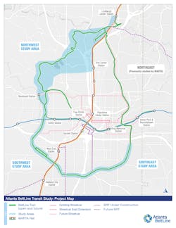
Atlanta BeltLine is launching the transit planning study for a 13.6-mile portion of the rail corridor around the 22-mile BeltLine loop. The study is funded by the Federal Transit Administration and will identify the preferred Atlanta BeltLine transit alignment and station locations in the northwest quadrant and will solidify the preferred station locations the southwest and southeast quadrants where the transit alignment has already been determined. Metropolitan Atlanta Rapid Transit Authority (MARTA) has already completed a study that defines alignment in the northeast quadrant.
Rail transit in the BeltLine corridor will complement and connect to MARTA’s existing heavy rail and bus networks and an extensive network of multi-use trails, creating a more robust and equitable transportation system for Atlanta, making the BeltLine more accessible to people, regardless of weather, ability or geography. The study builds upon previous reports, including the Atlanta BeltLine/Atlanta Streetcar System Plan (adopted by City Council in 2015), Record of Decision (published by the FTA and MARTA in 2012) and MARTA’s study of BeltLine eastside corridor from Lindbergh to I-20 (completed in 2021).
“Transit is at the heart of the BeltLine vision,” said Atlanta BeltLine President and CEO Clyde Higgs. “The BeltLine is about high-quality ways to connect people to jobs, health care, shopping, education and opportunity while making Atlanta a more mobile city. Rail transit is key to how we do that.”
Kimley-Horn & Associates will conduct the study, and it will take 24 months from kick-off to final deliverables. Activities will include field investigation, consolidation of previous studies, stakeholder and public outreach, environmental screening, equity considerations, service planning, ridership forecasting and financial planning. The project will specifically look at connectivity between the regional transit network and the regional trail network.
Light-rail transit is essential in a layered infrastructure approach to address current and future mobility needs due to the influx of people anticipated to move to Atlanta in the next few decades. Between April 2022 and April 2023, 66,730 people moved to metro Atlanta, bringing the population to 5.16 million. The Atlanta Regional Commission forecasts the 21-county Atlanta region will potentially add 2.9 million people by 2050, reaching a total population of 8.6 million.
The planning area for the northwest segment of the Atlanta BeltLine transit corridor is from Lindbergh Center MARTA Station on the north side of the BeltLine loop to Bankhead MARTA Station on the western side. The study continues along the southwestern and southeastern quadrants of the BeltLine loop to Glenwood Avenue.


