Cities worldwide struggle with traffic congestion – and it comes at a cost.
A 2012 Urban Mobility Study by Texas A&M's Transportation Research Institute calculated that traffic congestion in 2011 wasted $121 billion in the U.S. alone in time, fuel and money. Another study, this one from the Harvard Center for Risk Assessment, predicts that emissions from vehicles idling in traffic jams will result in 1,600 premature deaths and $13 billion in “total social costs” in the U.S. by 2020.
Such sobering statistics — coupled with staggering population growth that sends 60 to 70 million new residents to urban areas each year — have cities seeking transportation solutions. Some are finding them. By deploying advanced analytics and "smart technologies," pioneering cities are demonstrating how to make mass transit more appealing and roadways less congested.
Given budget constraints, costly transportation overhauls rarely happen in a year or two. But even incremental adoption of smart technologies can help. Here are five examples.
Keeping Dublin moving
Sensors and the data they produce help 1.2 million residents of Dublin, Ireland move efficiently through the city's extensive network of roads, tramways and bus lanes. The city's road and traffic department worked with IBM to integrate information (including geospatial data) from a citywide sensor network. Now they can monitor and manage traffic in real time. The data – from bus timetables, traffic detectors, closed-circuit cameras and GPS updates transmitted by city buses every 20 seconds – helps build a "digital map" of the city overlaid with real-time positions of Dublin’s 1,000 buses. Traffic controllers see the current status of the entire network at a glance. They can rapidly spot and drill down into a detailed visualization of areas experiencing delay, allowing them to implement traffic calming measures.
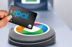
Sydney's Opal Card eases congestion at the gate
Hong Kong got the ticketless smart payment ball rolling before the turn of the century with its Octopus card; London followed with the Oyster card. Now Sydney, Australia is rolling out the Opal card. The intent is to make mass transit more efficient and more convenient – and thus more appealing. In Sydney's case, instead of standing in line to buy tickets, riders use Opal cards to tap on a card reader at the start of a trip and tap off at the end.
Transport for NSW introduced its electronic payment system in a progressive rollout, starting with ferries in 2012, then adding trains. Now, in spring 2014, it is testing bus routes. It also offers several fare incentives, including free travel after eight paid journeys in a week. In April 2014, Transport for NSW reported more than 165,000 people had signed up for Opal cards, using them for more than 6.5 million journeys and more than a million free trips.
Helping London commuters in real time
Transport for London (TfL) was a pioneer when it teamed with Microsoft in 2011 to give customers real-time data about journey options. As a first step, TfL wanted to do more with its data-rich London Underground TrackerNet system. The system provides real-time feeds about train movements to BBC and other partners, but it was only attracting about 1,000 hits a day. Working with Microsoft, TfL built an application programming interface that floated the TrackerNet data onto Windows Azure, Microsoft's cloud-based platform. That provided partners and developers a place to create apps built on top of the raw data.
What happened next? As TfL CTO Michael Gilbert explains it: “By the time Microsoft Services had set up the new system — in a matter of about six weeks — the TrackerNet website [was] handling 2.3 million hits a day."
Making transit riders feel safer in Atlanta
Like London, cities around the world are making data available for developers. In return, they are getting smartphone apps that help transit riders learn about route changes, find arrival times, calculate fares and the like. The Smart Cities Apps Gallery features numerous examples. But the Metropolitan Atlanta Rapid Transit Authority (MARTA) serving Georgia's capital city in 2013 introduced an app with a different focus. It aims to make transit users feel safer.
The free MARTA See & Say app makes it easy for riders to alert MARTA police about suspicious activity. The software is designed for environments with limited cell service, for example underground subway tunnels. If a customer loses service while using the app, the text or photo is sent to police dispatchers immediately once a signal is re-established. The app enables two-way communications, so riders can also receive and comment on alerts from MARTA Police and officials can request additional details from riders who report incidents.
Taking public transportation to the next level in Seoul
Seoul gets high marks for being one of the world's smartest, most connected cities and its transportation network is no exception. Its subway system, which transports some seven million passengers daily, draws high praise from travel writers. Along with smart payment systems, Seoul Metro offers 4G and Wi-Fi in all of its stations and subways (which are climate controlled and have seat warmers).
Seoul also pioneered Digital View terminals. Travelers interact with these kiosks to find optimal routes. They can also see street view maps, nearby restaurants, weather and more. Some stations even feature virtual grocery stores. Wall-length billboards that look like store shelves display images and prices of common products. Each sign includes a QR code; consumers shop by scanning products and their orders are delivered to their home or office within the day.
Jesse Berst is chairman of the Smart Cities Council, an organization of leading global companies formed to accelerate growth of smart cities worldwide by providing city leaders with access to technology counsel, financial tools, policy frameworks and more.


